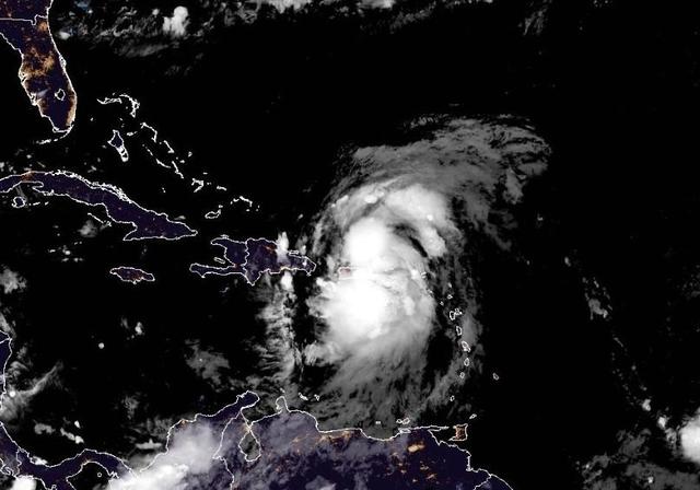
Tropical Storm Ernesto, a significant meteorological phenomenon, is currently advancing toward the Virgin Islands and Puerto Rico, prompting concerns among residents and authorities alike. As weather systems develop in the Caribbean region, it is crucial to examine the impact of such storms on local communities, infrastructure, and ecosystems. The trajectory of Tropical Storm Ernesto not only poses immediate threats but also raises questions about long-term climate patterns in the region.
The forecast indicates that Tropical Storm Ernesto will make landfall this evening, bringing with it heavy rainfall and strong winds. Meteorologists have warned that these conditions could lead to flooding, power outages, and potential damage to homes and businesses. The vulnerability of Puerto Rico's infrastructure remains a pressing issue since Hurricane Maria struck in 2017; recovery efforts are ongoing. Consequently, local governments are urged to implement emergency protocols to safeguard residents against possible evacuations or sheltering measures.
Ernesto has prompted hurricane watches in parts of the northeast Caribbean, including the Virgin Islands, where it's expected to intensify as it spreads heavy rain, strong winds and some coastal flooding through Wednesday.
current status: Ernesto is centered near the Leeward Islands and is moving quickly west-northwest. Bands of soaking rain packing gusty winds are spreading through the islands.
Puerto Rico has activated the National Guard and canceled public school classes ahead of the storm.
Ernesto is expected to strengthen and could become a hurricane tonight after it goes to the north of the Virgin Islands and Puerto Rico.
The path of the storm is projected to turn north over the western Atlantic and is expected to be near Bermuda on Friday.
As of 5 p.m. Atlantic Standard Time, the center of Ernesto was located about 135 miles east-southeast of San Juan, Puerto Rico.
Maximum sustained winds were at 60 mph, with the storm moving west-northwest at 18 mph.
The seasonal hurricane outlooks were notably aggressive because forecasters looking at the start of the season saw a combination of circumstances that didn’t exist in records dating back to the mid-1800s: record warm water temperatures in the Atlantic Ocean and the potential formation of the weather pattern known as La Niña.
La Niña occurs in the Pacific because of changing ocean temperatures, and it affects weather patterns globally. When it is strong, it typically provides a calm environment in the Atlantic; this allows storms to develop more easily and to strengthen without interference from wind patterns that might otherwise keep them from organizing.
Read more
Chick-fil-A fan favorite is back for the first time in 13 years with other new items Deadlier strain of Mpox is spreading in AfricaSarah H
Also on site :
- Gemini converts Google Docs to podcasts
- Jonathan Ross opens up about why he decided to quit alcohol
- Jason Isaacs says he was ‘involved’ in mystery off-screen White Lotus ‘drama’

